Log in
All resources
Create a design
9,296 Free Artworks of Map Collection
bibliothèque nationale de france
copper engraving print
british library
joan blaeu
atlas maior, vol 3 (germany) - joan blaeu, 1667 - bl 114.h(star).3
eran laor cartographic collection
maps in the stadsarchief amsterdam
daniel stoopendaal
atlas maior, vol 4 (netherlands) - joan blaeu, 1667 - bl 114.h(star).4
latin-language maps
maps of 's-hertogenbosch by braun & hogenberg
atlas beudeker
franz müller
carl schütz
eran laor cartographic collection
alexis-hubert jaillot
eran laor cartographic collection
gerard de jode
eran laor cartographic collection
willem blaeu
eran laor cartographic collection
maps by alexis-hubert jaillot
eran laor cartographic collection
alexis-hubert jaillot
eran laor cartographic collection
gerard de jode
eran laor cartographic collection
sanson maps of the holy land
cartouche (cartography)
maps by john rocque
maps in the stadsarchief amsterdam
daniel stoopendaal
maps in the stadsarchief amsterdam
hendrik de leth
maps of meeresteijn
hendrik de leth
maps in the stadsarchief amsterdam
daniel stoopendaal
maps in the stadsarchief amsterdam
hendrik de leth
atlas maior, vol 4 (netherlands) - joan blaeu, 1667 - bl 114.h(star).4
copper engraving print
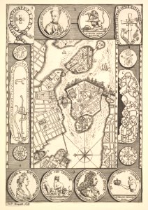
maps of bergamo city walls
maps in the museo correr
atlas maior, vol 3 (germany) - joan blaeu, 1667 - bl 114.h(star).3
copper engraving print
atlas maior, vol 3 (germany) - joan blaeu, 1667 - bl 114.h(star).3
copper engraving print
atlas maior, vol 3 (germany) - joan blaeu, 1667 - bl 114.h(star).3
copper engraving print
atlas maior, vol 3 (germany) - joan blaeu, 1667 - bl 114.h(star).3
copper engraving print
atlas maior, vol 3 (germany) - joan blaeu, 1667 - bl 114.h(star).3
copper engraving print
atlas maior, vol 3 (germany) - joan blaeu, 1667 - bl 114.h(star).3
copper engraving print
atlas maior, vol 4 (netherlands) - joan blaeu, 1667 - bl 114.h(star).4
copper engraving print
media contributed by university of illinois urbana-champaign university library
1702 maps of africa
atlas maior, vol 3 (germany) - joan blaeu, 1667 - bl 114.h(star).3
copper engraving print
atlas maior, vol 4 (netherlands) - joan blaeu, 1667 - bl 114.h(star).4
copper engraving print
atlas maior, vol 3 (germany) - joan blaeu, 1667 - bl 114.h(star).3
copper engraving print
atlas maior, vol 3 (germany) - joan blaeu, 1667 - bl 114.h(star).3
copper engraving print
atlas maior, vol 3 (germany) - joan blaeu, 1667 - bl 114.h(star).3
copper engraving print
atlas maior, vol 3 (germany) - joan blaeu, 1667 - bl 114.h(star).3
copper engraving print
atlas maior, vol 3 (germany) - joan blaeu, 1667 - bl 114.h(star).3
copper engraving print
atlas maior, vol 3 (germany) - joan blaeu, 1667 - bl 114.h(star).3
copper engraving print
atlas maior, vol 4 (netherlands) - joan blaeu, 1667 - bl 114.h(star).4
copper engraving print
atlas maior, vol 4 (netherlands) - joan blaeu, 1667 - bl 114.h(star).4
copper engraving print
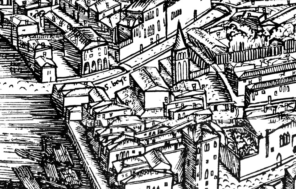
demolished churches in de barbari map
san basilio (venice)
1780s maps of the balkans
carl schütz
dutch 17th-century prints in the rijksmuseum amsterdam
maps in the rijksmuseum amsterdam
geographia universalis (1545) in the british museum
german renaissance,northern renaissance
bowes playing cards bm 1938,0709.57.1-60
augustine ryther
geographia universalis (1545) in the british museum
german renaissance,northern renaissance
maps from gallica
guides joanne
maps from gallica
guides joanne
maps from gallica
guides joanne
le royaume de france distingué by guillaume sanson
maps by nicolas sanson
map of the upper rhenian circle by sanson
1700s maps of north rhine-westphalia
maps by willem and johannes blaeu
17th-century maps of xaintonge
bibliothèque nationale de france
maps by tomas lopez
satirical prints in the british museum
works after robert dighton
1670s maps of rhineland-palatinate
maps of vangiones by sanson
bibliothèque nationale de france
maps by jakob van der schley
bibliothèque nationale de france
dheulland map of paris
illustrations from la perse, la chaldée et la susiane
bibliothèque nationale de france
bibliothèque nationale de france
tranquillo mollo
everett d. graff collection of western americana
maps by g. w. & c. b. colton & co.
19th-century paintings in the metropolitan museum of art
takaku aigai
maps of sandomierz by braun & hogenberg
maps of biecz by braun & hogenberg
maps of sandomierz by braun & hogenberg
maps of biecz by braun & hogenberg
maps of flensburg by braun & hogenberg
maps of itzehoe by braun & hogenberg
maps from the bibliothèque historique de la ville de paris
baroque
maps from the bibliothèque historique de la ville de paris
baroque
bibliothèque nationale de france
guillaume sanson
topographia helvetiae, rhaetiae et valesiae (1654) engravings
history of appenzell
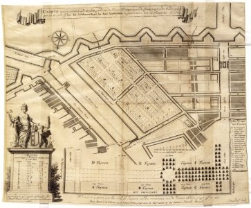
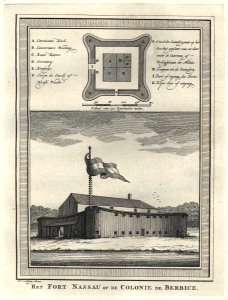
west-indische compagnie
1770
16th-century maps of lisbon
1580s maps of portugal
eran laor cartographic collection
claes jansz. visscher (ii)
drawings by johan frederik clemens in the statens museum for kunst
pencil
drawings by johan frederik clemens in the statens museum for kunst
pencil
old maps of neuf-brisach
jean-jacques lequeu
broadsheet prints from koninklijke bibliotheek - maps
broadsheet prints from koninklijke bibliotheek
19th-century portrait paintings in the musée de l'armée
nicolas gosse
maps of cyprus by mercator-hondius
eran laor cartographic collection
augustus kollner
pictorial maps
seven pilgrim churches of rome
churches in rome in art
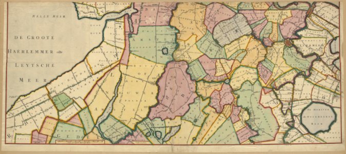
old maps of haarlem
haarlemmerhout
pieter nason
baroque
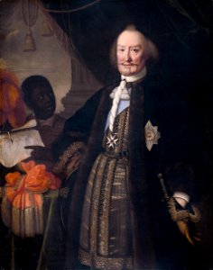
18th-century portraits in the national museum in poznań
józef wall
eran laor cartographic collection
alexis-hubert jaillot
1590s maps of transylvania
1590s maps of hungary
broadsheet prints from koninklijke bibliotheek - maps
broadsheet prints from koninklijke bibliotheek
paris depuis charles v jusqu'à charles ix d'après le plan de l'abbaye st-victor
maps of paris from paris musées
maps of tönning by braun & hogenberg
maps of husum by braun & hogenberg
broadsheet prints from koninklijke bibliotheek - maps
broadsheet prints from koninklijke bibliotheek
navigantium atque itinerantium bibliotheca
1744 fleurons
maps in the stadsarchief amsterdam
daniel stoopendaal
maps in the stadsarchief amsterdam
daniel stoopendaal
maps in the stadsarchief amsterdam
daniel stoopendaal
maps in the stadsarchief amsterdam
daniel stoopendaal
18th-century maps of stockholm
realism
old maps of the kingdom of naples
1700s maps of italy
18th-century portrait paintings in the national maritime museum, london
john francis rigaud
map of the circle of upper saxony by sanson
bibliothèque nationale de france
le royaume de france distingué by guillaume sanson
1724 maps of france
bibliothèque nationale de france
noviciat des jésuites (paris)
1667 sanson map of africa
1669 maps of africa
4801 - 4900 of 9,296
Next page
/ 93